Bước tới nội dung

Bản mẫu:Thông tin khu dân cư/testcases

34°03′B 118°15′T / 34,05°B 118,25°T / 34.050; -118.250
Bách khoa toàn thư mở Wikipedia

Case 0: Los Angeles

[sửa mã nguồn]
So sánh hai bên
{{Thông tin khu dân cư}}{{Thông tin khu dân cư/sandbox}}
Thành phố Los Angeles
—  Thành phố  —

Hiệu kỳ

Ấn chương
Tên hiệu: L.A., the City of Angels (Thành phố các thiên thần), the Entertainment Capital of the World

Vị trí của Los Angeles và vùng phụ cận tại tiểu bang California
Tọa độ: 34°03′B 118°15′T / 34,05°B 118,25°T / 34.050; -118.250
Quốc giaHoa Kỳ
Tiểu bangCalifornia
QuậnLos Angeles
Định cư1781
Hợp nhất4 tháng 4, 1850
Chính quyền
 • KiểuHội đồng thị trưởng
 • Thị trưởngEric Garcetti
 • Biện lý thành phốMike Feuer
 • Cơ quan điều hànhHội đồng thành phố
Diện tích
 • Thành phố498,3 mi2 (1.290,6 km2)
 • Đất liền469,1 mi2 (1.214,9 km2)
 • Mặt nước29,2 mi2 (75,7 km2)  5.8%
 • Đô thị1.667,9 mi2 (4.319,9 km2)
Độ cao233 ft (71 m)
Dân số (2006)[1]
 • Thành phố3.849.378
 • Mật độ8.205/mi2 (3.168/km2)
 • Đô thị12.950.129
 • Vùng đô thị17.775.984
 • Mùa hè (DST)PDT (UTC-7)
Mã bưu điện90001–90068, 90070–90084, 90086–90089, 90091, 90093–90097, 90099, 90101–90103, 90174, 90185, 90189, 91040–91043, 91303–91308, 91342–91349, 91352–91353, 91356–91357, 91364–91367, 91401–91499, 91601–91609 91367, 91401–91499, 91601–91609
Websitewww.ci.la.ca.us/
Thành phố Los Angeles
Flag of Thành phố Los Angeles
Official seal of Thành phố Los Angeles
Nicknames: 
L.A., the City of Angels (Thành phố các thiên thần), the Entertainment Capital of the World
Vị trí của Los Angeles và vùng phụ cận tại tiểu bang California
Bản mẫu:Ifnoerror then show
Quốc giaHoa Kỳ
Tiểu bangCalifornia
QuậnLos Angeles
Định cư1781
Hợp nhất4 tháng 4, 1850
Government
 • TypeHội đồng thị trưởng
 • Thị trưởngEric Garcetti
 • Biện lý thành phốMike Feuer
 • Cơ quan điều hànhHội đồng thành phố
Area
498,3 mi2 (1.290,6 km2)
 • Land469,1 mi2 (1.214,9 km2)
 • Water29,2 mi2 (75,7 km2)  5.8%
 • Urban
1.667,9 mi2 (4.319,9 km2)
Elevation
233 ft (71 m)
Population
 (2006)[1]
Bản mẫu:Fix comma category
Population
 (2006)[1]
Bản mẫu:Fix comma category
 • Density8.205/mi2 (3.168/km2)
 • Urban
Bản mẫu:Fix comma category
 • Metro
Bản mẫu:Fix comma category
Time zoneUTC-8 (PST)
 • Summer (DST)UTC-7 (PDT)
Mã bưu điện
90001–90068, 90070–90084, 90086–90089, 90091, 90093–90097, 90099, 90101–90103, 90174, 90185, 90189, 91040–91043, 91303–91308, 91342–91349, 91352–91353, 91356–91357, 91364–91367, 91401–91499, 91601–91609 91367, 91401–91499, 91601–91609
Area codes213, 310/424, 323, 661, 747/818
Websitewww.ci.la.ca.us/

Case 1: Detroit

[sửa mã nguồn]
So sánh hai bên
{{Thông tin khu dân cư}}{{Thông tin khu dân cư/sandbox}}
Detroit
NativeName
OtherName
—  City  —
City of Detroit
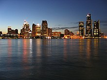
Skyline of Detroit

Hiệu kỳ

Ấn chương
Tên hiệu: Motor City, Motown, Rock City, The D
Khẩu hiệu: "Speramus Meliora; Resurget Cineribus"
(Latin for, "We Hope For Better Things; It Shall Rise From the Ashes")

Location in Wayne County, Michigan
Tọa độ: 42°19′53″B 83°02′45″T / 42,33139°B 83,04583°T / 42.33139; -83.04583[2]
CountryUnited States
StateMichigan
CountyWayne County
Founded1701
Incorporation1806
Chính quyền[3]
 • KiểuStrong Mayor-Council
 • MayorKwame Kilpatrick (D)
 • Deputy MayorJohn Doe
 • Deputy Mayor's SidekickJane Doe
 • City ManagerJohn Doe, Jr.
 • City ClerkJohn Doe, III
Diện tích[4]
 • City3,700 km2 (143,0 mi2)
 • Đất liền3,590 km2 (138,8 mi2)
 • Mặt nước110 km2 (4,2 mi2)  2.9%
 • Đô thị3,350 km2 (1.295 mi2)
 • Vùng đô thị10,130 km2 (3.913 mi2)
Độ cao[2]200 m (600 ft)
Dân số (2006)[5]
 • City871.121
 • Thứ hạng554th
 • Mật độ240/km2 (610/mi2)
 • Đô thị3.903.377
 • Vùng đô thị4.468.966
 • Mùa hè (DST)EDT (UTC-4)
Websitewww.detroitmi.gov
Infobox footnotes placed here
Detroit
NativeName
OtherName
City
City of Detroit
Tall buildings with city lights at dusk, reflected over still dark water
Skyline of Detroit
Quartered flag. Top left: blue with 17 white stars. Top right: Red with 3 golden lions. Bottom left: White with 5 gold fleur-de-lis. Bottom right: 13 alternating white and red stripes, diagonally downward. Center is covered by the city seal in color
Light blue seal with two women, "THE CITY OF DETROIT", "MICHIGAN", and the city motto in Latin
Nicknames: 
Motor City, Motown, Rock City, The D
Mottoes: 
"Speramus Meliora; Resurget Cineribus"
(Latin for, "We Hope For Better Things; It Shall Rise From the Ashes")
Detroit covers most of the northeast part of Wayne County, which in turn is in the far southeast of Michigan.
Bản mẫu:Ifnoerror then show
CountryUnited States
StateMichigan
CountyWayne County
Founded1701
Incorporation1806
Government
 • TypeStrong Mayor-Council
 • MayorKwame Kilpatrick (D)
 • Deputy MayorJohn Doe
 • Deputy Mayor's SidekickJane Doe
 • City ManagerJohn Doe, Jr.
 • City ClerkJohn Doe, III
Area
 • City
3,700 km2 (143,0 mi2)
 • Land3,590 km2 (138,8 mi2)
 • Water110 km2 (4,2 mi2)  2.9%
 • Urban
3,350 km2 (1.295 mi2)
 • Metro
10,130 km2 (3.913 mi2)
Elevation200 m (600 ft)
Population
 (2006)[5]
Bản mẫu:Fix comma category
Population
 (2006)[5]
 • City
Bản mẫu:Fix comma category
 • Rank554th
 • Density240/km2 (610/mi2)
 • Urban
Bản mẫu:Fix comma category
 • Metro
Bản mẫu:Fix comma category
Time zoneUTC-5 (EST)
 • Summer (DST)UTC-4 (EDT)
Websitewww.detroitmi.gov
Infobox footnotes placed here

Case 2: Ziketan Town

[sửa mã nguồn]
So sánh hai bên
{{Thông tin khu dân cư}}{{Thông tin khu dân cư/sandbox}}
Ziketan Town
子科滩镇
—  Town  —
Ziketan Town trên bản đồ Trung Quốc
Ziketan Town
Ziketan Town
Location within China
Tọa độ: 35°35′19″B 99°59′12″Đ / 35,588525°B 99,986558°Đ / 35.588525; 99.986558
CountryTrung Quốc
ProvinceQinghai
PrefectureHainan
CountyXinghai
Established1953
Diện tích3.000 km2 (1.158 mi2)
Độ cao3.193 m (10,476 ft)
Dân số 10.000
 • Mật độ3,3/km2 (8,6/mi2)
Ethnicity
 • Tibetan80%
Qinghai e-Gov Portal
Ziketan Town
子科滩镇
Bản mẫu:Ifnoerror then show
CountryTrung Quốc
ProvinceQinghai
PrefectureHainan
CountyXinghai
Established1953
Area
3.000 km2 (1.158 mi2)
Elevation
3.193 m (10,476 ft)
Population
Bản mẫu:Fix comma category
 • Density3,3/km2 (8,6/mi2)
Ethnicity
 • Tibetan80%
Time zoneUTC+8 (China Standard Time)
Qinghai e-Gov Portal

Case 3: Ponte San Giovanni

[sửa mã nguồn]
So sánh hai bên
{{Thông tin khu dân cư}}{{Thông tin khu dân cư/sandbox}}
Ponte San Giovanni
—  Frazione  —
Ponte San Giovanni trên bản đồ Ý
Ponte San Giovanni
Ponte San Giovanni
Location of Ponte San Giovanni in Italy
Tọa độ: 43°05′23″B 12°26′44″Đ / 43,08972°B 12,44556°Đ / 43.08972; 12.44556
CountryItaly
RegionUmbria
ProvincePerugia (PG)
ComunePerugia
Diện tích
 • Tổng cộng18 km2 (7 mi2)
Độ cao190 m (620 ft)
Dân số
 • Tổng cộng13.296
 • Mật độ740/km2 (1,900/mi2)
Tên cư dân[Ponteggiani] Lỗi: {{Lang}}: văn bản có thẻ đánh dấu in nghiêng (trợ giúp)
 • Mùa hè (DST)CEST (UTC+2)
Postal code06135
WebsiteCircoscrizione n° 8, Comune di Perugia
Ponte San Giovanni
Bản mẫu:Ifnoerror then show
CountryItaly
RegionUmbria
ProvincePerugia (PG)
ComunePerugia
Area
 • Total
18 km2 (7 mi2)
Elevation
190 m (620 ft)
Population
Bản mẫu:Fix comma category
Population
 • Total
Bản mẫu:Fix comma category
 • Density740/km2 (1,900/mi2)
Demonym[Ponteggiani] Lỗi: {{Lang}}: văn bản có thẻ đánh dấu in nghiêng (trợ giúp)
Time zoneUTC+1 (CET)
 • Summer (DST)UTC+2 (CEST)
Postal code
06135
Dialing code075
WebsiteCircoscrizione n° 8, Comune di Perugia

Case 4: Gorssel

[sửa mã nguồn]
So sánh hai bên
{{Thông tin khu dân cư}}{{Thông tin khu dân cư/sandbox}}
Gorssel
—  Dorp  —
Tọa độ: 52°12′B 6°12′Đ / 52,2°B 6,2°Đ / 52.200; 6.200
CountryNetherlands
ProvinceGelderland
MunicipalityLochem
Diện tích
 • Tổng cộng1,807 km2 (698 mi2)
Dân số (2006)
 • Tổng cộng1,807
 • Mật độ0,0.010/km2 (0,0.026/mi2)
Secret password"Luite Klaver"
Favorite colorTurquoise
Gorssel
Dorp
Bản mẫu:Ifnoerror then show
CountryNetherlands
ProvinceGelderland
MunicipalityLochem
Area
 • Total
1,807 km2 (698 mi2)
Population
 (2006)
Bản mẫu:Fix comma category
Population
 (2006)
 • Total
Bản mẫu:Fix comma category
 • Density0,0.010/km2 (0,0.026/mi2)
Secret password"Luite Klaver"
Favorite colorTurquoise

Case 5: Herāt

[sửa mã nguồn]
So sánh hai bên
{{Thông tin khu dân cư}}{{Thông tin khu dân cư/sandbox}}
Herāt
هرات
—  City  —
Overview of Herat City
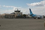
Herat Airport
Citadel of Herat
Friday Mosque of Herat Musalla Complex
Tên hiệu: Pearl of Khorasan
Herāt trên bản đồ Afghanistan
Herāt
Herāt
Location in Afghanistan
Tọa độ: 34°20′31″B 62°12′11″Đ / 34,34194°B 62,20306°Đ / 34.34194; 62.20306
Country Afghanistan
ProvinceHerat Province
Độ cao920 m (3,020 ft)
Dân số (2006)
 • Tổng cộng397,456
 [6]
Herāt
هرات
City
Nickname: 
Pearl of Khorasan
Bản mẫu:Ifnoerror then show
Country Afghanistan
ProvinceHerat Province
Elevation
920 m (3,020 ft)
Population
 (2006)
Bản mẫu:Fix comma category
Population
 (2006)
 • Total
Bản mẫu:Fix comma category
 [6]
Time zoneUTC+4:30 (Afghanistan Standard Time)

Case 6: Baghdad

[sửa mã nguồn]
So sánh hai bên
{{Thông tin khu dân cư}}{{Thông tin khu dân cư/sandbox}}
Baghdad
—  City  —
بغداد Baġdād
Baghdad trên bản đồ Iraq
Baghdad
Baghdad
Tọa độ: 33°20′0″B 44°26′0″Đ / 33,33333°B 44,43333°Đ / 33.33333; 44.43333
Country Iraq
ProvinceBaghdad
Established762 AD.
Chính quyền
 • KiểuMayor-council
 • Thành phầnBaghdad City Advisory Council
 • MayorSaber Nabet Al-Essawi
Diện tích
 • Tổng cộng2.260,2 km2 (8,727 mi2)
Độ cao34 m (112 ft)
Dân số
 • Ước tính (2011)7.216.040
 • Thứ hạng1st
 [7][8]
 • Mùa hè (DST)No DST (UTC)
Baghdad
City
بغداد Baġdād
Bản mẫu:Ifnoerror then show
Country Iraq
ProvinceBaghdad
Established762 AD.
Founded byAbu Jafar al-Mansour
Government
 • TypeMayor-council
 • BodyBaghdad City Advisory Council
 • MayorSaber Nabet Al-Essawi
Area
 • Total
2.260,2 km2 (8,727 mi2)
Elevation
34 m (112 ft)
Population
Bản mẫu:Fix comma category
Population
 • Estimate 
(2011)
Bản mẫu:Fix comma category
 • Rank1st
 [7][8]
Time zoneUTC+3 (Arabia Standard Time)
 • Summer (DST)No DST

Tham khảo

  1. ^ “Population Estimates for the 25 Largest U.S. Cities based on 1 tháng 7, 2006 Population Estimates” (PDF). US Census Bureau. Truy cập ngày 28 tháng 6 năm 2007. Kiểm tra giá trị ngày tháng trong: |accessdate= (trợ giúp)
  2. ^ a b "Detroit". Hệ thống Thông tin Địa danh. Cục Khảo sát Địa chất Hoa Kỳ. http://geonames.usgs.gov/pls/gnispublic/f?p=gnispq:3:::NO::P3_FID:1617959. Truy cập 2009-07-25. . Source for coordinates and elevation.
  3. ^ government_footnotes test
  4. ^ area_footnotes test
  5. ^ “US Census July 1, 2006 est”.
  6. ^ “B. Demography and Population” (PDF). Afghanistan Statistical Yearbook 2006, Central Statistics Office. Ministry of Rural Rehabilitation and Development. Truy cập ngày 12 tháng 1 năm 2011.
  7. ^ Estimates of total population differ substantially. The Encyclopædia Britannica gives a 2001 population of 4,950,000, the 2006 Lancet Report states a population of 7,216,040 in 2011.
  8. ^ "Cities and urban areas in Iraq with population over 100,000", Mongabay.com