
Tập tin:Lava Flow on Volcán de Fuego, 2016.jpg
Không có độ phân giải cao hơn.
Lava_Flow_on_Volcán_de_Fuego,_2016.jpg (720×480 điểm ảnh, kích thước tập tin: 315 kB, kiểu MIME: image/jpeg)
Tập tin này từ Wikimedia Commons. Trang miêu tả nó ở đấy được sao chép dưới đây. Commons là kho lưu trữ tập tin phương tiện có giấy phép tự do. Bạn có thể tham gia. |
| Miêu tả |
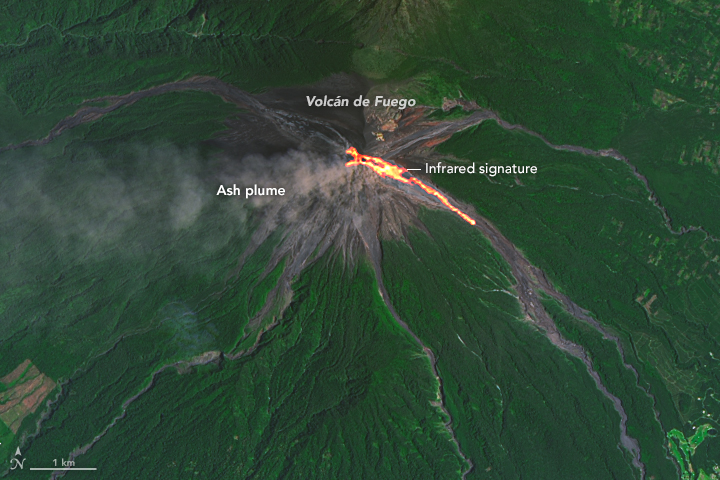
English: On September 7, 2016, the Operational Land Imager (OLI) on Landsat 8 captured this image of lava spilling down the slopes of Guatemala’s Volcán de Fuego, one of Central America’s most active volcanoes.
According to reporting from the Instituto Nacional de Sismologia, Vulcanologia, Meteorologia, e Hidrologia (INSIVUMEH), the latest bout of activity began on September 4, when lava rose as high as 200 meters (650 feet) above Fuego’s crater rim. Plumes of ash have reached heights of about 850 meters (2,800 feet). The image is a composite of natural color (OLI bands 4-3-2) and shortwave Infrared (OLI band 7). Shortwave infrared light (SWIR) is invisible to the naked eye, but strong SWIR signals indicate increased temperatures. The volcano is located about 70 kilometers (40 miles) west of Guatemala City, Guatemala. |
|||||
| Ngày | acquired September 7, 2016 | |||||
| Nguồn gốc | http://earthobservatory.nasa.gov/IOTD/view.php?id=88722&src=eoa-iotd | |||||
| Tác giả | NASA Earth Observatory image by Joshua Stevens, using Landsat data from the U.S. Geological Survey. | |||||
| Giấy phép (Dùng lại tập tin) |
|

Lịch sử tập tin
Nhấn vào ngày/giờ để xem nội dung tập tin tại thời điểm đó.
| Ngày/giờ | Hình xem trước | Kích cỡ | Thành viên | Miêu tả | |
|---|---|---|---|---|---|
| hiện tại | 20:54, ngày 23 tháng 9 năm 2016 | | 720×480 (315 kB) | Tillman | {{Information |Description ={{en|1=On September 7, 2016, the Operational Land Imager (OLI) on Landsat 8 captured this image of lava spilling down the slopes of Guatemala’s Volcán de Fuego, one of Central America’s most active volcanoes. Accord... |
Trang sử dụng tập tin
Có 1 trang tại Wikipedia tiếng Việt có liên kết đến tập tin (không hiển thị trang ở các dự án khác):
Sử dụng tập tin toàn cục
Những wiki sau đang sử dụng tập tin này:
- Trang sử dụng tại ar.wikipedia.org
- Trang sử dụng tại id.wikipedia.org
- Trang sử dụng tại mk.wikipedia.org
- Trang sử dụng tại pt.wikipedia.org
- Trang sử dụng tại sl.wikipedia.org
- Trang sử dụng tại ta.wikipedia.org
- Trang sử dụng tại th.wikipedia.org